|
Digital Humanities Workbench |
Home page > Special topics > Digital archaeology > Data analysis Data analysisArchaeological data may be analysed in various ways, both during the data collection stage and as part of the academic research that is based om the findings. In synthesising research, the information obtained from several excavations is combined. Different sites, complexes or find categories can be compared within a (micro)region, within a specific theoretical framework.
Statistical analysisArchaeologists use statistical methods and techniques for all kinds of applications, such as the classification of collections of objects, predicting potential settlement sites or interpreting datings produced by C14 analyses. The most commonly used applications are quite basic and can be performed in Microsoft Excel. For more advanced statistical applications, PAST (PAleontological STatistics), a freeware package that is relatively easy to use, is quite commonly used [Reference]. For specialist work, more and more archaeologists are using R, an open source environment that requires some knowledge of programming languages, but can be easily linked to other applications such as GIS.
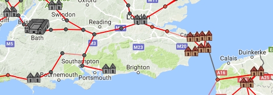
GISIn scientific research, GIS is mainly used to analyse spatial relationships between archaeological objects and their environment, both at the level of the excavation and at regional level. GIS has proved to be a key tool in explaining settlement patterns ('predictive modeling'), because it allows archaeological data to be easily linked to non-archaeological information, such as soil maps or elevation models. Unlike in historical sciences, the visualisation of research results with GIS is less important in archaeology. Although cartography is an essential part of fieldwork reporting, there are few examples of truly interactive archaeological maps. Two good examples are the Roman 'route planner' Omnes Viae, and the atlas of Roman rural settlements in England.
In the Netherlands, the website Archeologie in Nederland is an important source of archaeological geo-information, where visitors can access all information managed by the Cultural Heritage Agency of the Netherlands.
Agent-based modelling (ABM)Over the last decade, archaeological research has used computer simulation to an increasing extent in order to better understand complex processes in the past. Most of these simulations focus on socio-economic processes. The appeal of these types of models, usually called agent-based modelling (ABM), is that they can provide insight into how, for example, economic production developed in the past, using relatively simple means. The VU project Finding the limits of the limes used this method to study how agriculture was organised in the border area of the Roman Empire. The most widely used software for ABM is NetLogo. This is a programming language with a graphical interface that makes it possible to visualise the models in charts and maps.
Network analysisThe creation and analysis of formal networks is a fairly recent ICT application in the field of archaeology. It is based on the principle that archaeological objects can provide information about the socio-economic relationships between groups of people in the past. Network analysis makes it possible to investigate how objects spread through a network, which can say something about the level of contact between groups and their mutual hierarchy. Network analysis can also be used to reconstruct transport and communication networks, and to determine the extent to which one's position in the network can lead to greater control over the network. In the project ' Finding the Limits of the Limes , which was also mentioned before, network analysis was used to understand how Roman castella could have been supplied. In Lieve Donellan's Urbanet project, network analysis is used to investigate finds from Greek and Etruscan tombs in southern Italy. A large number of software packages are available for performing and visualising formal network analysis, of which Cytoscape is the most user-friendly option. However, it is not possible at this time (2017) to link this software directly to GIS.
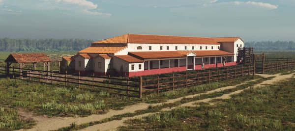
2D and 3D reconstructions3D reconstructions are often used in the presentation of archaeological research. These can be made based on pictures or can drawn digitally. They usually have an informative purpose, besides illustrating the subject of the research in question. Researchers typically try to integrate new knowledge obtained from archaeological research in these drawings.
 Reconstruction of a Roman Villa at Hoogeloon, by Mikko Kriek. For the VU project Challenging Testaccio, a Spatial Data Infrastructure app was developed. This cultural biography app bridges the gap between ancient Rome and the urban development of modern Rome. |
Other topics in this section: Introduction Preparation Data collection |
