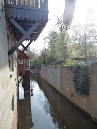
| 's-Hertogenbosch, Poor Clares |
 | |
| Quay wall along the Binnendieze, originating from the convent of the Poor Clares | Full Map on Geoplaza. |
| IDNR: | H61 |
| Parish: | 's-Hertogenbosch |
| Municipality: | 's-Hertogenbosch |
| Patron Saint: | - |
| Alias: | Rijke Claren (Rich Clares) |
| Diocese: | Liège |
| Diocese II: | 's-Hertogenbosch |
| Province: | Brabant |
| Province II: | Brabant (Spaans, later Staats) |
| Gender: | f |
| Development: | Poor Clares following the rule of Urban IV 1349* |
| Filiation: | founded either by the convent in Brussels (B) or the one of Cologne (G) |
| End of monastic life: | 1647 (?) |
| Narrative Sources (CK): | - |
| Narrative Sources (NS): | - |
| Manuscripts (SV): | - |
| Archives: | SA Den Bosch: 184 |
| Literature: | Hoekx (1983) 20-21; Roggen (1995) 93-102; Kuijer (2000) 175; Van Drunen nr. 8; Sanders (2016) 80; 109 |
| Third Order: | - |
| Monasticon Batavum: | I 109 nr. 5; S 80-81 nr. 5 |
MeMO: | - | |
Van Deventer: | chapel; 'Clara'; [17] | |
National monument: | |
| Coordinates: | 149/411 |
Archaeological Monument: | 16796 (tc) | |
Archaeological Status: | hav | |
Archaeological Activities: | surveillance 1995 | |
Archaeological Publication: | Bloemink (1997) | |
| First mention: | 1349 |
| Last mention: | 1647 |
| ENK code: | ME-Z019-009 |
 Monasteries
Geoplaza Home
Monasteries Map
Monasteries
Geoplaza Home
Monasteries Map
